LAB
OPENING HOURS
Open 24 hour daily inclusive of weekend
\ public holidays
|
|
|
|
|
LAB |
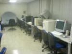
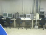
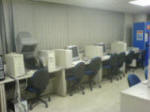
Graphics Lab of School of Computing | |
| LOCATION | S16 #09-01 | |
|
OPENING HOURS
|
Open 24 hour daily inclusive of weekend \ public holidays |
|
| ACCESS | Only open to related lab courses students | |
![]() _
_![]() _
_![]() _
_![]()
Introduction
Graphics lab is providing teaching area in multimedia field for undergraduate students.
Geomagic Studio ver 8.0
![]()
![]()
![]()
QuickStart
ACDSee ver 8.0
This photo management software organizes your shots and allows you to view, fix, and share them quickly and easily.
ACDSee makes organizing your photos exactly that: Quick and easy, so you can play with and share the great photos you’ve got. Get Photos fast from any storage device, and ACDSee automatically categorizes your shots based on metadata information (e.g., keywords, size, date taken). There is a new password protected Private Folders to store confidential information.
Get an array of rapid full-screen quick viewing tools, time-saving Print Layouts that make printing easier and less confusing, as well as powerful email options, slide shows, CD/DVD burning, and web album tools that make sharing photos as easy as can be. Enhance photos with quick fixes like red-eye removal, color cast removal, exposure adjustments, and the Photo Repair tool.
Autodesk Inventor Professional ver 10
Autodesk Inventor®
Professional software provides a combination of industry-specific tools that
extend the capabilities of Autodesk Inventor® for completing complex machinery
and other product designs.
Built on the Autodesk Inventor application, Autodesk Inventor Professional
includes several different modules.
Autodesk Inventor Studio for Integrated Rendering and Animation
The new Autodesk Inventor Studio feature provides built-in, state-of-the-art rendering and animation directly in the design environment. explore design concepts and present design intent with compelling renderings and animations that improve communication and reduce costs by creating photorealistic prototypes
![]()
Sony Vegas ver 6.0
Deep Exploration
Deep Exploration Standard and CAD Editions are desktop applications used to search, open, view, and manage a comprehensive set of 2D, 3D, animation, video, and audio assets. A variety of tools allow you to translate, optimize, animate, and render files and publish to a wide range of formats. The Deep Exploration CAD Edition includes support for 3D CAD models, and integration and support for the PDF Publishing and PMI Modules, Deep Server, and publishing to Microsoft Office applications.
![]()
note: This is a big demo file, it will takes about
5 minutes to load and play in web browser
TerrianView Ver 2.2
The
TerrainView application is a state of the art Virtual Reality based software
solution that facilitates the interactive visualization of high-resolution 3D
terrain data over the inter-and intranet. Due to ViewTec’s advanced
software technology and innovative data management concepts, large amounts of
data may be processed in real-time. Digital elevation models, high resolution
orthophotos, satellite images, 3d buildings and vector data provide the real
time application with the information to display excellent high quality
representations of complex terrains and landscapes.
Overview of distinguishing features of TerrainView
• Import of 3D models
Currently the supported data formats are Multigen OpenFlight, Terrex TerraPage,
CG2 VT, 3D Studio Max 3ds, and others.
• Various modes of navigation
TerrainView provides various modes of navigation such as view mode, flight mode,
low level flight (ground following), and explore view.
• Points of interest
Freely definable points of interest may be coupled with arbitrary text, 3D
objects, or hyperlinks.
• Advanced flight path editing
Easy definition of flight paths with smooth interpolation for position and
orientation. Flight paths can be coupled to both 3D models and camera.
• Weather visualization
For the generation of realistic scenes, TerrainView offers a wide palette of
weather conditions.
• Configurations
Any scene consisting of terrain, 3D models, flight paths points of interest and
weather conditions can be saved in configurations files for instant access in
future sessions.
• Arbitrary resolution screen shots
The resolution of screen shots calculated from the current view are only limited
by the hardware.
• Generation of image sequences for digital video
TerrainView™ offers a simple way to create video movies either by direct
interaction or from flight paths.
• Planning tools
A collection of tools such as distance and angular measurements, plan blending,
and object fading.
ArcGIS ver 9.0
This software is a mobile mapping and geographic information system (GIS) technology. Mobile computing is bringing fundamental changes to the way geography is utilized with the ability to bring work with you and to interact directly with the world. Mobile GIS compromises the integration of four technologies: GIS, lightweight hardware, the global positioning system (GPS), and wireless communication.
ArcGIS provides database access, mapping, GIS and GPS integration to users out in the field via handheld and mobile devices. Data collection is efficient and significantly improved with immediate data validation and availability.
Computer Specification
| Brand model | Specification | Quantity |
| Taknet P4 1.8GHz | 1GB/40GB | |
| Dell Optiplex GX150 P3 1GHz | 512MB/20GB | |
Printer
cpn901 color printer
Projector
Equipment Operation Instruction
Elumens Vision Station
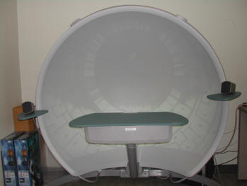
The VisionStation has a large parabolic shell that is used to display the image projected by the wide-angle lens.
In areas such as space design and simulation (flight, driving or battlefield simulation), this new display completely changes the way you interact with the digital environment!
Key benefits of the VisionStation are:
Operating Instruction for Elumens Visionstation
Kaiser Head Mounted Display Proview 60
Cyber Glove
3D Digitizer Vivid 900 (Minolta)
Ekahau
Ekahau Positioning Engine™ (EPE), the most accurate positioning platform for the Wi-Fi. EPE is a powerful software solution that enables a variety of new location-based applications for Wi-Fi tags, PDAs, laptops, and any 802.11a/b/g-enabled devices. The Positioning Engine includes a standalone Manager application and two ways (a Java SDK and a language-independent YAX™ TCP-protocol) for reading client location (x, y, floor), speed, heading, and logical area information, such as "Conference Room".
Reference
![]()
![]()
![]()
![]()
Phantum Haptic Device
Gypsy 3 Wireless Motion Capture System